In this edition of In The Spotlight, Tyler Fisk, the Conservancy’s new Stewardship Manager, tells us a little about how we use GIS, his time growing up in northern New York, and why forest fragmentation is his biggest environmental concern.

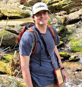
Tyler in the field, surveying a new property.
Where did your passion to work to save nature begin?
I grew up in Green Island, New York along the confluence of the Mohawk and Hudson Rivers. I spent countless hours fishing, hiking and exploring their shorelines. I am grateful to have family in the Catskills and Adirondacks which allowed me to explore the largest protected area in the contiguous United States. I knew I wanted to make this more than a passion, but my life. This led me to Paul Smith’s College, the College of the Adirondacks, where I received a Bachelor of Science in Natural Resources Conservation Management.
In one or two sentences could you sum up what you do for the Conservancy?
As Stewardship Manager and GIS Analyst I am responsible for stewardship project development and management, management aspects of our In-Fee and Conservation Easement portfolio, and management of GIS and database.
What is your favorite part of your job day to day?
My favorite part of my job is always the field work. Being able to work on projects across the 7,945 acres (and growing) of Conservancy land gives me the energy to keep doing what we do best, conserving natural and forested lands forever.

Welsh Mountain Nature Preserve
Do you have a favorite preserve that you have visited? Why is it your favorite?
My favorite is Welsh Mountain Nature Preserve. The dualistic nature of Welsh, having both recreation and restoration areas, sets a great example of landscape level conservation. Its also currently our largest preserve.
Do you have a story you can share with us about a funny or interesting thing that you’ve come across either out on our preserves or in previous work?
I don’t have a specific story, but my favorite part is always seeing what’s left over in the woods. Whether that be an abandoned car, old railroad tracks, or a sketchy tree stands. Seeing the past historical uses and how it effects the current condition of a property always gets me thinking.
What is your favorite function of GIS?
GIS is how many conservation organizations manage and visualize data. I’m a landscape level thinker and GIS allows me to strategically plan for conservation projects. We can use data to visualize what invasive species have been detected in our area, which lands are conserved, or how to prioritize acquisitions.

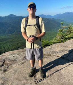
Tyler hiking on Hurricane Mountain in Elizabethtown, NY.
As far as environmental issues, either locally or globally, what concerns you the most? What gives you hope?
I’m worried about forest fragmentation and parcelization. The largest holders of forested lands in Pennsylvania are private and those landowners might all have different priorities in how they manage their forests. Wildlife do not see those boundaries, but they do feel the impact of the individual’s management (or lack thereof) on the landscape. Forests are a uniting force. Whether you are a hunter, fisherman, paddler, hiker, forester or farmer, most agree that we need healthy forests intact. What gives me hope is that most landowners that I talk to, want to do the right thing and are willing to be educated about new conservation practices.
It’s your day off – what will we find you doing?
You’ll typically find me doing the same things that led me to this line of work: fishing, hunting, biking, hiking and camping with my partner and daughter. When I’m not outside, you can find me cooking, enjoying a good book or cheering on the greatest sports team, the Boston Red Sox.
